What if climate change is not fate?
What if it is land, water, and heat
fallen out of balance?
What if it can turn back?
↓ ScrollIt is a data-and-map-powered brain for Pakistan. It layers water, soil, crops, livestock, people, energy, and carbon district by district, then finds the exact places where fixing one thing fixes many things at once.
In simple words: it answers one question first: where should we act, and what action will do the most good?
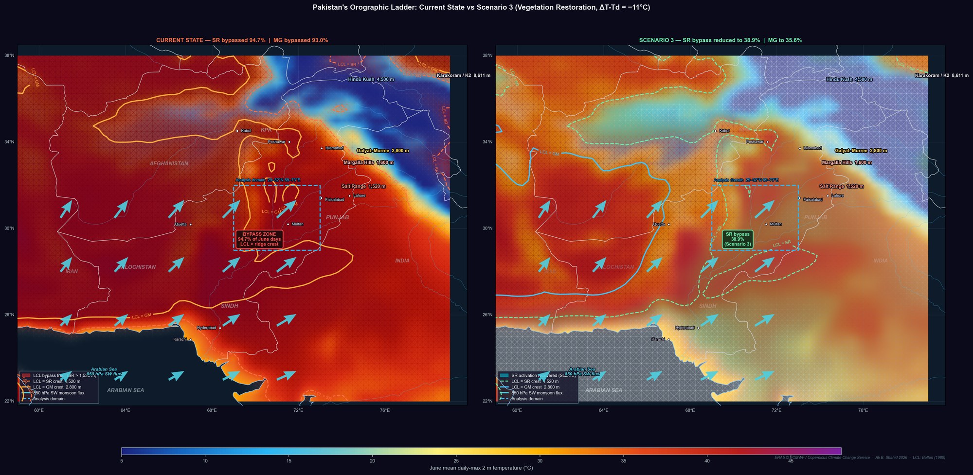
Its strength is the orographic ladder: on a mostly single elevation profile, the land rises from Karachi to Nanga Parbat, which means Pakistan can catch weather systems across sea, plains, foothills, and mountains.
The gift is real. The problem is timing and placement: rainfall arrives at the wrong places, at the wrong time. When the lifting condensation level sits too high, moisture bypasses the lower ridges instead of raining where it should.
The scientific basis includes the peer-reviewed In Defence of the Biotic Pump plus five open papers behind LandIQ, including moisture corridors, biome radiative forcing, surface-to-TOA coupling, and the broader land-atmosphere mechanism.
What LandIQ does with that: it turns the mechanism into action by telling you when, where, and how to intervene so water, carbon, energy, farming, and livelihoods move together.
You give us the decision. We tell you where to act. This is the premium recommendation product.
Best for people who need an answer, not just a map.
Basin-scale decision support. Where to sequence restoration, water, and adaptation spending.
LandIQ gives a convergence atlas with ranked sites, interventions, cost, and projected cascade.
Operator-partner intelligence. Which district and intervention to fund.
LandIQ gives independent pre-investment diligence on site, mechanism, cascade, and failure modes.
Pre-MRV site intelligence. Which sites will hold, fail, or stack credits.
LandIQ gives site selection, cascade projection, monitoring baseline, and a failure-mode brief.
Convergence maps for grants and boards. Where limited dollars create the strongest impact.
LandIQ gives convergence maps, mechanism grounding, and support for board and donor conversations.
Asset-coordinate climate intelligence. What survives diligence across water, heat, flood, and degradation risk.
LandIQ gives coordinate-level convergence scoring, quarterly refreshes, alerts, and audit-ready reporting.
Capital is limited. Problems are not.
In simple wordsLandIQ is a decision tool for land and climate strategy. It layers water, soil, crops, livestock, people, energy, and carbon district by district to show where one action can fix many things at once.Go to desktop for the full experience.
LandIQ is a data-and-map-powered brain for Pakistan. It layers water, soil, crops, livestock, people, energy, and carbon district by district, then finds the exact places where fixing one thing fixes many things at once.
In simple words: it answers one question first: where should we act, and what action will do the most good?
Pakistan is one of the most climatically gifted countries on Earth, even though it is usually described only as climate-risked.
Its strength is the orographic ladder: on a mostly single elevation profile, the land rises from Karachi to Nanga Parbat, which means Pakistan can catch weather systems across sea, plains, foothills, and mountains.
The gift is real. The problem is timing and placement: rainfall is arriving at the wrong places, at the wrong time. In the LCL work, when the lifting condensation level sits too high, moisture bypasses the lower ridges instead of raining where it should.
The scientific basis does not rest on one paper alone. It includes the peer-reviewed In Defence of the Biotic Pump plus five open papers in the active research program behind LandIQ, including moisture corridors, biome radiative forcing, surface-to-TOA coupling, and the broader land-atmosphere mechanism.
Together, that work supports the Pakistan LCL and orographic-ladder framing: this is not just a climate-damage story, but a physical mechanism that can be read, tested, and acted on.
What LandIQ does with that: it turns the mechanism into action by telling you when, where, and how to intervene so water, carbon, energy, farming, and livelihoods move together.
The phone version keeps this simple. Open the tier that matches your decision and ignore the rest.
Best for: teams that already know which layer they want, like Water, Carbon, or Energy.
What you get: quarterly layer refreshes, alerts, and delivery in usable spatial formats.
Model: annual subscription, outputs only.
Best for: people who want ranked outputs rather than raw layers.
What you get: scenario-based district rankings, quarterly refreshes, and event-triggered alerts.
Model: annual subscription, synthesis stays proprietary.
Best for: capital allocators with real assets or holdings to monitor.
What you get: coordinate-level refreshes, alerts, and portfolio climate exposure reporting.
Model: annual subscription, scope depends on asset count.
Best for: clients with a clear specification and a defined technical ask.
What you get: custom modeling, data acquisition if needed, and transferable outputs.
Model: scope-based project, from short engagements to multi-year work.
Best for: people who need an answer, not just a map.
What you get: a full convergence run, ranked trigger points, intervention logic, cost, cascade, and failure risks.
Model: one decision, one signed recommendation, delivered as a premium engagement.
The same engine serves different readers. What changes is the decision they need to defend.
Decision: where public money should go first and how to defend that sequence to Cabinet, donors, and the press.
What they get: a convergence atlas with ranked sites, interventions, cost, and projected cascade.
Decision: which compact, district, or project has the strongest mechanism and the clearest counterfactual.
What they get: independent pre-investment diligence on site, mechanism, cascade, and failure modes.
Decision: where to commit capital before the first baseline survey.
What they get: site selection, cascade projection, monitoring baseline, and a failure-mode brief.
Decision: where a theory of change has the highest leverage and strongest defense to donors.
What they get: convergence maps, mechanism grounding, and support for board and donor conversations.
Decision: which assets or deals are robust and where the portfolio is physically exposed.
What they get: coordinate-level convergence scoring, quarterly refreshes, alerts, and audit-ready reporting.
This phone version is shortened on purpose. If you stay here, read it in three steps: what LandIQ is, why Pakistan matters, and what proves the engine.
What this means: LandIQ is useful when one site can solve several problems at once. It helps you see the mechanism, choose the site, and understand the cascade.
When pressures converge in the same landscape, interventions stop being scattered — they start compounding. The engine produces this at three scales: atmospheric (Example 1 · Salt Range bypass, 45 years of ERA5), district (Example 2 · Matiari, worked end-to-end), and crop × practice (Example 3 · sugarcane water waste + biochar recovery). Five products deliver it (see Pricing).
No more guesswork. No more picking sites by availability or politics. When you can see where multiple pressures and opportunities overlap, every dollar, every tree, every tonne of biochar goes exactly where it does the most.
A place with high fertilizer costs, available crop residue, and declining water tables is not three problems. It is one site where biochar cuts input costs, builds soil, and restores water. The overlap is the leverage.
The same tight coupling that lets degradation cascade through a landscape can be reversed. Restore the right site and the effects travel: downstream water quality improves, adjacent farms see moisture return, the atmospheric signal shifts.
The crises are real. So is the opportunity hidden inside them.
Pakistan uses more water per hectare than almost any country in its income bracket. Efficiency gains in agriculture are water gains for everyone.
Farmers in high-input districts spend PKR 20,000–30,000/acre on synthetic fertilizer. Every rupee exposed to exchange rate risk and commodity swings.
Rice straw in Sindh and Punjab. Sugarcane tops in lower Punjab. Feedstock for biochar, compost, and energy, set on fire every harvest.
The same Indus floodplain that grows Pakistan's food absorbed a catastrophic flood. Recovery siting needs spatial intelligence, not guesswork.
Each layer is a spatial question with a spatial answer. Water. Carbon. Energy. Plus seven coupled inputs. Select one to read what that answer looks like, per district, per season.
Where do all seven answers point to the same coordinates?
Between the Arabian Sea and K2, Pakistan's terrain intersects five successive condensation stages. A single atmospheric variable, the lifting condensation level, decides how many are active. Across 45 years of ERA5 reanalysis, the answer is two. The other three are not blocked by geography. They are compressed by a missing land surface. That compression can be released.
Analysis based on forthcoming LandIQ / Ali Bin Shahid ESSOAr preprint — submission in progress, DOI to follow.
The gap between Pakistan's current water capture and its terrain-defined ceiling is the largest unrealized natural capital endowment in South Asia. Closing it is a water-security, food-security, and climate-resilience problem solved by the same intervention.
LandIQ is the only intelligence practice that couples atmospheric physics with district-level political economy across ten layers — water, biosphere, farming, feedstock, livestock, people, energy, carbon, terrain, and the convergence scenarios that synthesise them — all at district resolution, in one decision-grade map. The same engine reads atmospheric levers (Example 1), trigger-point districts (Example 2), and crop-specific water balances (Example 3) without switching methodology. We return a ranked set of sites where one well-placed action lifts production, earns exports, protects the country's water, and the atmosphere over it. Pakistan is where we start.
The same intelligence layer informs cloudburst response, watershed planning, and restoration targeting — executed through engagements we lead (see Ali’s track record).
Engine output on a real 1,459 km² district — the readout our Diagnostic tier produces for a specific decision.
A ~1,459 km² district in lower Sindh where six of the eight LandIQ layers converge. It sits on the Indus, anchors Pakistan's second-largest Nili-Ravi buffalo belt, grows cotton and sugarcane on the same soils, and burns ~140,000 tonnes of crop residue every October. A single well-placed intervention here cascades through water, livestock, farming, feedstock, and people at once.
One physical footprint does five jobs at once: diverts crop residue from burn to biochar, redirects dairy effluent from canal to compost, re-wets the root zone via canal repair, re-establishes shade and fodder via silvopasture, and rebuilds the Indus riparian corridor 2–3 km back from the channel.
Cascade projections use coupled hydrology + biomass + dairy models ground-truthed against PBS district data and Sindh Agriculture Facts & Figures 2024. Sensitivity bands reported in the full brief.
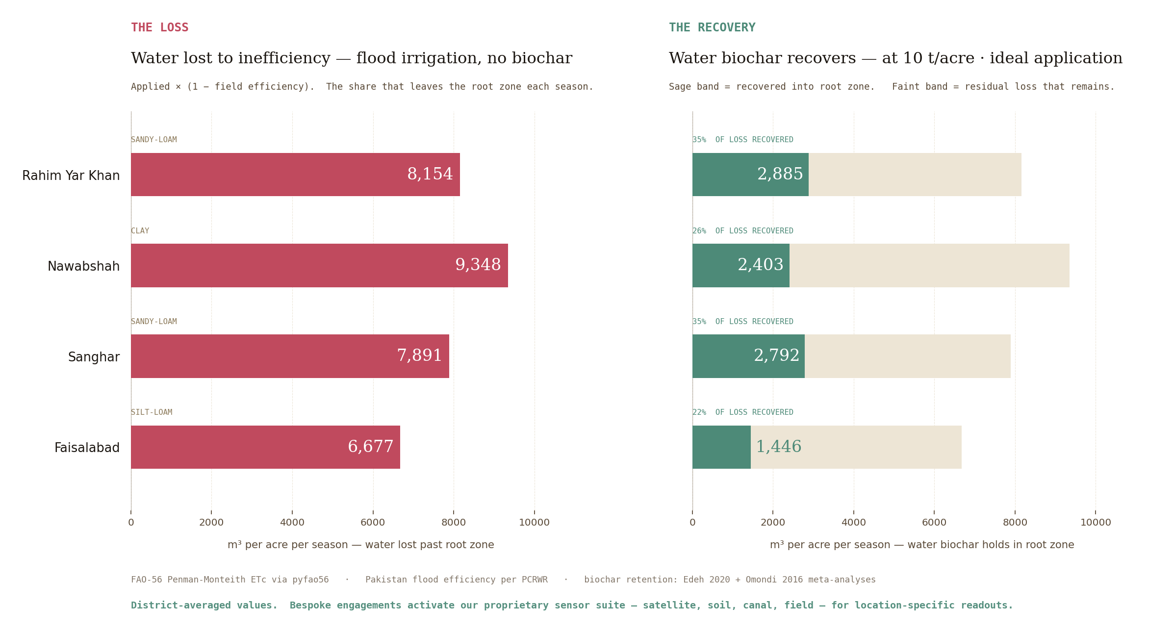
Engine output for the question “where is the water going, and how much of it can biochar hold back?”
Sugarcane fields take in 2,500–3,600 mm of water per season — roughly what the crop demands. Only a third of it reaches the root zone. The rest drains past as deep percolation, runoff, and wet-soil evaporation. Biochar worked into the soil profile holds more of the applied water where the crop can use it. The chart below shows how much of the inefficiency gap biochar recovers across four sugarcane districts.
Left — The loss. Water lost past the root zone each season under current flood irrigation, in m³ per acre, for four sugarcane districts. Right — The recovery. Water that biochar at 10 t/acre (ideal application) holds back in the root zone, same four districts, same scale. Bar length compares directly across the two panels: rust is what goes missing; sage is what comes back.
District-averaged values. Our Bespoke Diagnostic tier activates the proprietary sensor suite — satellite, soil, canal, field — for location-specific readouts tied to the exact coordinates where you operate. The district average drops away; site-specific numbers replace it. See Diagnostic →
The engine produces this readout for every district × crop × practice combination in Pakistan. Five buyer types use the output differently.
Same engine, different buyer: governments, multilaterals, project developers, NGOs, and investors all use the same map differently.
The same underlying intelligence — ten layers, district resolution, trigger-point ranking — resolves differently depending on what decision you’re defending. Here’s what LandIQ delivers to each kind of reader.
Short version: subscriptions give ongoing maps and signals, Bespoke builds to your specification, and Diagnostic tells you where to act first.
Bespoke and Diagnostic are available today — consult-led, scope-based. Atlas, Signals, and Portfolio Pulse are subscription products launching in 2026 as LandIQ transitions from judgment firm to platform. Founding clients contact us to join early-access cohorts.
Atlas sells you the facts — subscribe to the layers you need. Signals sells you what they mean — subscribe to pre-built convergence scenarios. Portfolio Pulse watches your specific asset coordinates live — for funds, insurers, and capital allocators. Bespoke builds what you specify — a one-time custom project. Diagnostic tells you where to act — a one-time premium recommendation, reputation staked. Data spine cited across all five. On Atlas, Signals, and Portfolio Pulse the synthesis methodology is proprietary — you buy outputs, not the engine. On Bespoke, methodology + models transfer to the client. On Diagnostic, methodology is disclosed in detail under engagement but remains LandIQ IP.
The raw intelligence stack. Subscribe to the layers your decision domain needs — Water alone for a canal authority, Carbon for a VCM funder, Energy for an IPP developer, or the full ten for a ministry. Quarterly refresh per layer, standing dashboard, GeoTIFF / GeoJSON delivery.
Pre-built convergence scenarios — the synthesis Atlas can't give you. Ranked district lists per objective, quarterly refresh, event-triggered alerts (e.g., "Matiari risk score jumped Q3 2026"). Subscribe to one scenario or a bundle that matches your decision stream.
Built for funds, insurers, and capital allocators. You give us the asset coordinates you actually care about — farms, fund holdings, insurance policies, infrastructure — and we run the full convergence engine against each one on a continuous cycle. Quarterly refresh, event-triggered alerts ("Nawabshah drought signal moved from 0.42 to 0.68 in Q3"), annual portfolio-climate-exposure report built to hold up under LP and regulator audit.
Custom modelling, custom dataset generation, multi-year programs, embedded team. You bring the specification; we deliver to your brief. Transferable, reproducible, yours.
We run the convergence synthesis weighted for your question — where water, carbon, energy, and the seven coupled inputs point to the same districts — ground-truthed at the top candidates, delivered as a signed brief: here is where to act, what it costs, what cascades out, what could go wrong, and why we'd stake our reputation on it.
Khurram Irshad is an entrepreneur with a thirty-year track record of executing cutting-edge projects, including patenting a process to reuse textile wastewater. He is the Managing Director of Indus Biochar, which is partnering with PlantVillage+ to scale Climate-Smart Agriculture in Pakistan. He holds a Masters in Industrial Management from Stony Brook University. As Co-founder and Chairman of LandIQ, he oversees the organization’s long-term direction and client relationships.
Twenty years in systems engineering. A decade on coupled land–atmosphere systems. Peer-reviewed work in hydrology and thermal forcing. LandIQ is the instrument for locating where restoration carries furthest in Pakistan.
Every degraded landscape contains the map of its own recovery. The coupling that drove collapse is the same coupling that carries restoration. The question was never whether recovery is possible. It was always: where do you start?
Featured on Investing in Regenerative Agriculture as "one of the few who can model and calculate water cycle restoration."
Today, each engagement is bespoke. The pipeline that backs them becomes a product once the pipeline is proven.
Spatial intelligence assembled per-project. Satellite-based analysis, convergence reports, strategic plans, and advisory engagements across water, agriculture, and restoration.
Automated ingestion from satellite, government, and field sources. Convergence scoring validated against live deployment outcomes. Bioacoustic biodiversity layer in development.
Self-serve access. Query any district. Export convergence reports. API for MRV integration, carbon registries, and project developers.
Why trust it: LandIQ sits on published atmospheric research, standard water-model methods, and Pakistan-specific calibration.
Peer-reviewed atmospheric science at the foundation. Established crop-water modeling and hydrological standards in the middle. Proprietary Pakistan-calibrated synthesis at the base. The engine cites the world's top research and agency standards as anchors; the coupling is ours.
Peer-reviewed: In Defence of the Biotic Pump (2025) — DOI.
Open preprints (ESSOAr · under review · code + data open on GitHub): Moisture corridors, Amazon and Congo DOI · Biome radiative forcing coefficients DOI · Surface energy partitioning to TOA DOI · Subarctic hydroelectric boundary-layer modification DOI · Subarctic dams forcing the AMOC DOI.
Public datasets: ERA5 · CHIRPS · GRACE-FO · SMAP · WaPOR · Copernicus GLO-90 · MERIT Hydro · ESA WorldCover 2021 · ESA CCI Biomass · Hansen Global Forest Change · VIIRS fires · WorldPop · PBS Digital Census 2023 · PBS Livestock Census 2024 · OCHA Pakistan admin-2 · OpenStreetMap · PCRWR Lower Indus · NEPRA tariffs. Full data lineage disclosed under engagement.
Cross-referenced external research: Waleed & Sajjad (2025) ML flood susceptibility DOI · Edeh 2020 + Omondi 2016 biochar meta-analyses · Cohen (1984) · Jalal (2014) · Lieven (2011) on institutional-belt geography · Woolf et al. (2010) on biochar carbon · van Donkelaar et al. on satellite PM2.5 · Peel et al. (2007) on Köppen · Zaigham et al. (2009) on Pakistan geothermal · Qureshi (2008), Aslam (2016) on salinity · ICG regional reports.
Image credits: Energy background — Jhimpir Wind Farm 2012 by Muzaffar Bukhari, CC BY-SA 2.0. Carbon background — Mangrove Forest Sindh by Ayazan57, CC BY-SA 4.0. Flood strip — Level Basin Flood Irrigation, public domain, USDA Natural Resources Conservation Service (Jeff Vanuga).
We work with organizations, governments, and investors who want their next intervention to land at the site where one action carries five outcomes.
Contact Us